
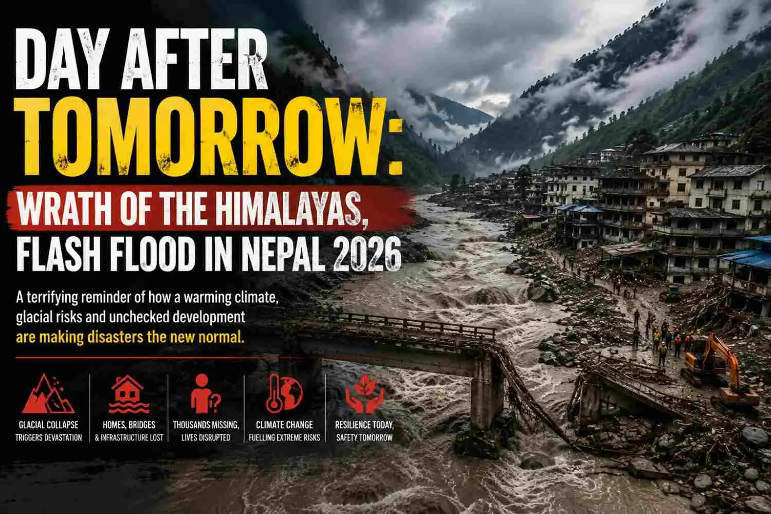
| Summary Actively evolving Himalayas have spread their wrath once again, at present the World is gripped with the images of Glacial Lake Outburst Flood (GLOF) of Nepal, this year. Recent episodes of urbanization and developments in the name of mega infrastructure have disturbed Himalayas to such an extent that disasters have become much more frequent than ever. |
| Keywords Himalayas, GLOF, Nepal flash flood |
The Kedarnath disaster of 2013 had popularized the term GLOF, acronym of Glacial Lake Outburst Flood. This year has witnessed another such episode in Nepal following the one at South Lhonak Lake of Sikkim in 2023. Glacial lake outburst flood (GLOF) takes place when ice blocks with huge number of rocks fall down in the glacial lakes supplying great amount of water and debris. The water holding capacity of the glacial lakes exceeds and after breaching the morainic embankment, water gushes out flooding the entire surrounding.
By Dr Kanailal Das
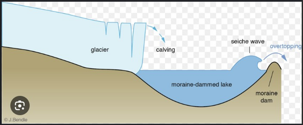
Fig 1: Glacial Lake Outburst Flood, a schematic diagram (Source: Antarcticglaciers.org)
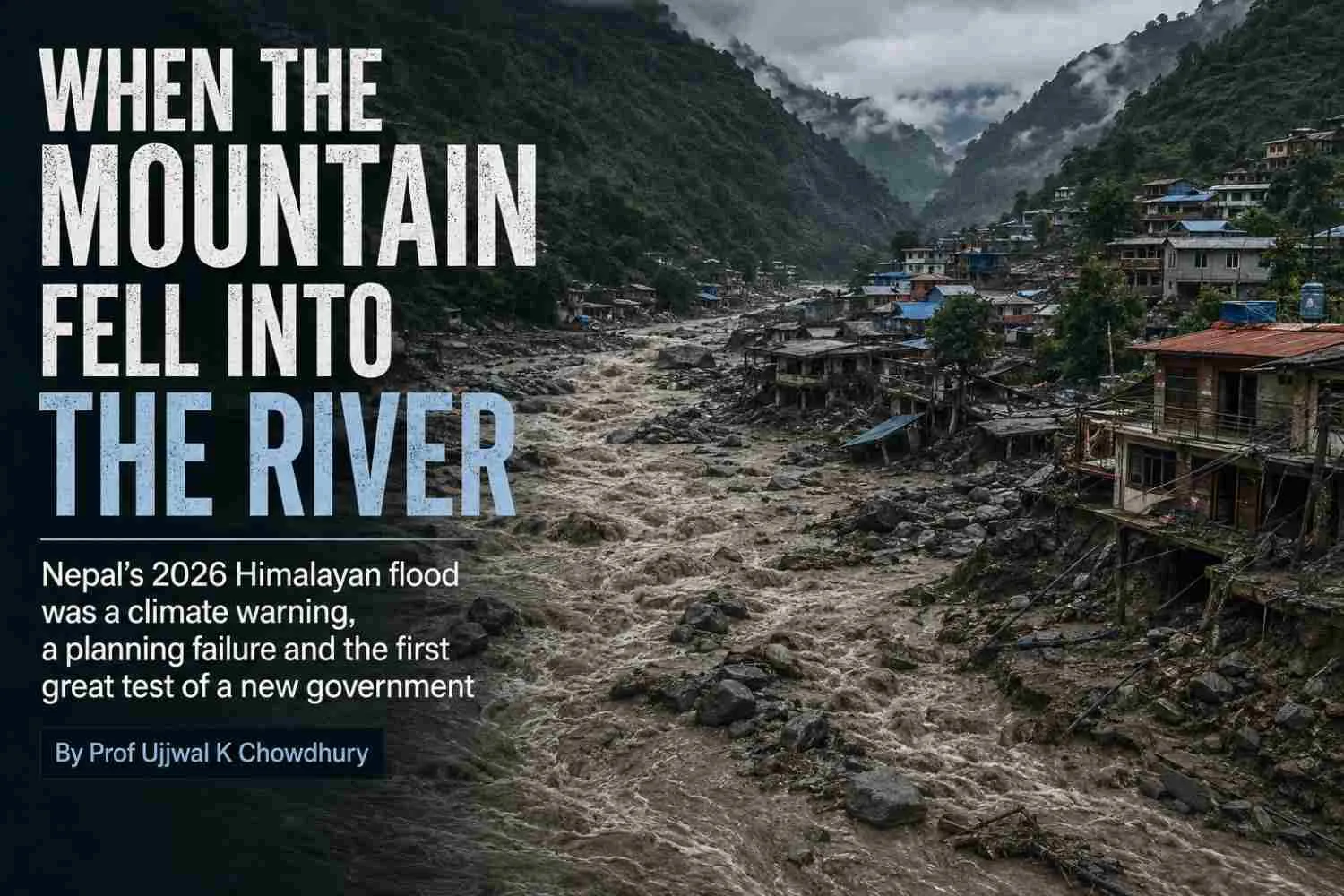
An unimaginable disastrous flash flood flood took place in Nepal Tibet border on 26th August, 2026 at the confluence of Bhote Koshi and Trishuli rivers. Primarily it was established that a huge block of glacier collapsed and fell nearly 1000m downstream. This block of ice with englacial moraines (rocks within the glacier) instantly supplied enormous water and glacial debris.
Generally, all glaciers have glacial lakes where glaciers start melting. Snow melt water beneath the glaciers is common in the high mountains. Thousands of glacial lakes beneath the glaciers are commonly found in Indian
Himalayas.
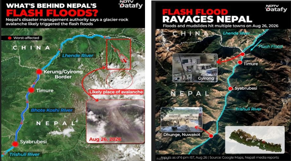
Fig 2: Locations affected by the flash flood (Source: NDTV Datafy)
Nepal -Tibet border disaster has destroyed large number of bridges, roads, buildings and hydro power infrastructure. Rescue operations were very tough due to rugged terrain. The local community of the settlement was under the thick layer of mud and remnants of the collapsed infrastructure.
Course of events in Nepal disaster:
High mountains - steep slopes - glacial melting due to warming - detached glacial block - huge amounts of debris and water supplied to glacial lake - breaching of the lake boundary - lake outburst - flow of water, mud and debris - settlement and infrastructure along the river swept away - bridges and road connectivity wiped away - death and missing humans and animals.
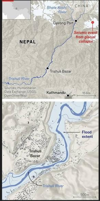
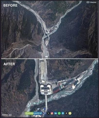
Fig 3: Pre and Post scenario of Nepal flood (The Economist, moneycontrolcom, abc news)
The disaster took place of August 26, 2026 occurred at the Gyirong - Rasuwagadhi gorge. It is the point where crossing roads via the Himalayas is possible between Nepal and China. The narrow place between two rivers is associated with hydro power infrastructure, heavily constructed zone of roads, custom facility and trade. The route across the location was being used by thousands of Mount Kailash pilgrims. Before 2011 the crossing was associated with very little infrastructure development with a rough road connectivity. The area experienced earthquake and landslides in the year 2015. A bridge was badly damaged. In 2017, the crossing was upgraded as an international dry port between Nepal and China. China also built a new bridge, 110 m Friendship Bridge beside the earthquake- damaged crossing site. The crossing and the dry port areas became an area of dense infrastructural development. Again, in July, 2025 a flash flood swept away the bridge. After that a temporary Bailey bridge had reopened the crossing.
Number of missing people rises to 2,482, including 320 Indians, as Nepal disaster toll hits 584. Nepal accounted for 579 deaths and 1,924 missing and Tibet reported five death and 558 missing.
Rescue teams on both sides of the border were repeatedly forced to reassess and retreat Fryday as an unstable barrier lake overflowed into Bhote Koshi river, sent a fresh surge downstream and halted rescue.
After a brief interval, another Avalanche dumped an estimated 50,000 cubic metres of ice debris. Satellite images showed post disaster formation of a great lake in the course of the river.
13 bridges along the river were swept away as the disastrous flood hit Rasuwa district of Nepal. Road connectivity was heavily destroyed. It took an arduous 50 hours after the mighty flash flood for the Chinese rescue teams to reach the core disaster zone around Gyirong dry port on Nepal - Tibet border using boats, ropes and heavily - lift drones. Thirty-seven tourists from West Bengal are missing in Nepal. A total of 39 persons of West Bengal were missing. Two of them have been rescued.
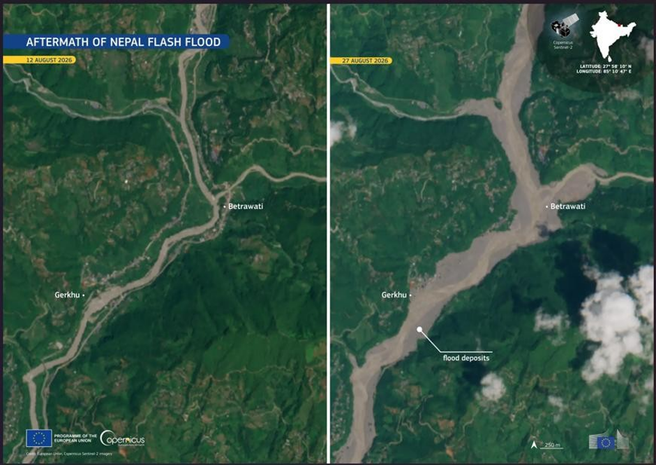
Fig 4: Satellite imagery showing aftermath of Nepal Flash Flood, 2026 (EU Space Program)
Nepal is now monitoring the mountain glaciers near the glacier collapse zone. Satellite images show cracks in the glacier raising concern over fresh flash floods.
Some information regarding the loss of life:
The Times of india,28th August reported : No trace of 50 persons from Maharashtra and 37 from Tamilnadu. Among the Indians untraced in the Nepal Disaster 50 Kailash Manasa Sarovar yatris were from Maharashtra. At least 37 out of 57 pilgrims from Tamil Nadu and Puducherry are missing.
Isha Sadhguru X Post :The whereabouts of 77 foreign nationals of Isha Foundation's Kailash Yatra, part of Isha Sacred Walks remained missing after the china immigration check post at Gyirong in Tibet was swallowed by the running water wall.
On August 27, 84 Indian nationals were rescued from Nepal including 63 workers at under - construction Trishuli 1 hydro power project.
Around 200 Indian pilgrims on the Tibet side seek help for evacuation. Five groups of Indian pilgrims are missing till date.
According to the latest reports the death toll from the Bhote Koshi -Trishuli disaster rose to 675 in Nepal on Saturday night, with 2,426 people still missing. Rescue teams are engaged in searching operations in glacial debris filled valleys, riverbanks and the tunnels of hydro power projects.
Chinese authorities reported seven deaths and 554 people missing at Gyirong dry port on Saturday morning.
Indian authorities revised down the number of Indian nationals unaccounted for in Nepal to 275 on Saturday evening, saying contact was reestablished with about 50 people. (Vishant Agarwala,The Times of india, August 30, 2026).
According to the geologists the speed of Bhote Koshi river flow exceeded 55 km /hour in some stretches of the river. That is 15.3 m per second. A man cannot run so fast, most probably a man can run 3/4 m per second. In some parts of the river valley where there was no highland to take shelter men ran over the pathway along the river valley and got submerged within the swift disastrous flow of water and glacial debris. At the time of disaster there was no such heavy rainfall. The sky was almost fully clear. A shopkeeper of Trishuli market in Nuyakote said, “We were warned by the local authority to leave the market as soon as possible, we got a brief time to save us, but my family is lost."
A bus carrying Manas Saravor pilgrims took a shelter in a comparatively high place, but some buses in front of us got no time and washed away in the surge with the pilgrims. Mallinath Kalkundi of Kanatataka told the reporter after the incident.
However, danger lurks somewhere: The disaster is not over
Satellite images indicate in the upstream there are two glacial lakes, one of the two lakes is full to the brim with huge amount of snow melt water. There is high probability of another glacial lake outburst flood in the same region.
Glacial Lake Outburst Flood: Episodes from Indian Himalayas
Thirteen glacial lakes in Uttarakhand in India are highly vulnerable for glacial lake outburst flood. In Indian Himalayas around 200 glacial lakes are recorded as unsafe and 25 of these lakes are considered of very high risk. The glacial Lake Outburst Flood, (GLOF) disaster in Nepal Wednesday, 26 August, 2026, has revived discussion on monitoring and management of the glacial lakes in Indian Himalayas. Himalayan ranges are the host of as many as 7,500 of them and 4,700 glacial lakes are situated in Ganga river basin with a catchment area over 2.5 lakh km2.
One of the worst GLOF took place on October 3 midnight, 2023 producing 14.7 cubic metres glacial debris in the South Lhonak Lake in Sikkim. Several hydro power assets and settlements downstream were wiped out. This is a classic example of how a GLOF can transform a highaltitude glacial detachment into a major regional disaster.
Glacial block detachment - ice with englacial moraines - supply of water and glacial debris - water holding capacity of South Lhonak Lake exceeded - Lake Outburst took place -- huge amount of water and glacial debris supply to the Teesta water - hydro power infrastructure and part of settlement were wiped away - affected settlements downstream, causing loss of life and resources.
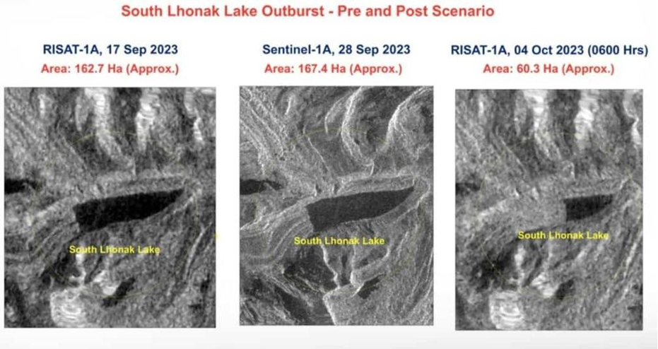
Fig 5: Pre and post South Lhonak Lake outburst (ICIMOD; Sattar et al., 2021)
In June 2013 the famous Kedarnath Temple region and the settlements along the river Mandakini experienced rainfall induced glacial lake outburst flood.
Cloud burst, Extreme rainfall - rapid melting of snow and ice - landslides - debris supply to the lake behind Kedarnath Temple - Chora Bari Lake outburst - devastating flood around Kedarnath Temple and Mandakini river valley - Rambara settlement was completely destroyed.
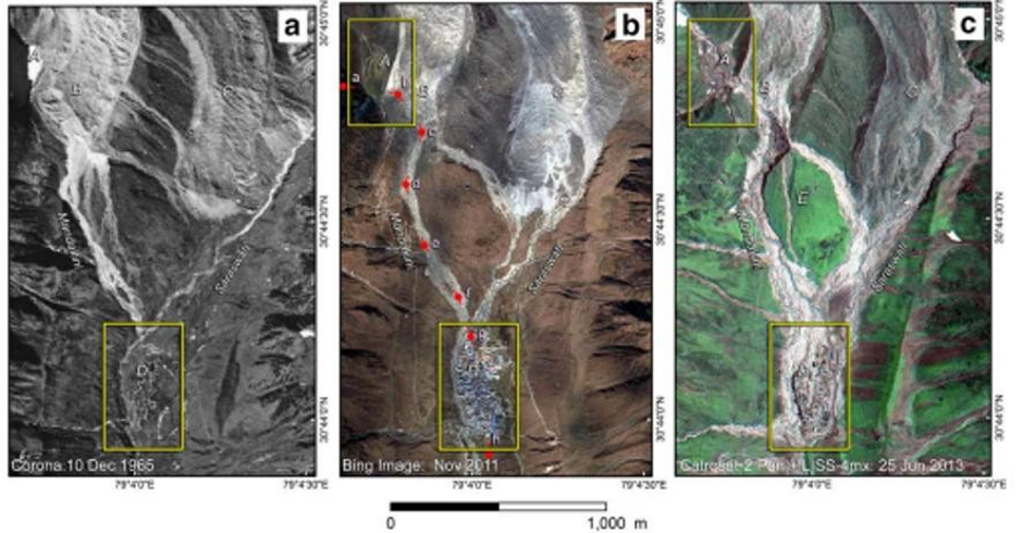
Fig 6: Pre, syn and post flood situation, Kedarnath, 2013 (Bandyopadhyay and Kar, 2014)
Other worst affected areas were Gaurikund, Sonprayag - Guptkashi, Agastyamuni and Rudraprayag. According to Government assessment 169 persons were dead and 4,021 people were reported missing. But local information indicated thousands of people were dead. The Kedarnath Disaster affected more than nine million people across Uttarakhand in various ways, including loss of homes, roads, bridges, communication and livelihoods.
Rapid climate change causing glacial melting accentuates the genesis of GLOFs. As we tend to speeden up our so-called development in the name of smart cities and macro infrastructure the ensuing flood gups the whole settlement in seconds. Himalayas is still actively evolving, with unstable debris which is geologically very fragile and any unplanned construction without catering to the geology and climate is sure to invite apocalypse.
Response to Glacial Lake Outburst Floods:
As a response to the Sikkim disaster National Disaster Management Authority, NDMA had set up a high-level coordination committee on GLOF disaster risk reduction.
To take necessary steps to lessen the severity of the GLOF:
Identifying the high mountains glacier - monitoring the change in the size of glaciers - Mapping the glacial lakes - monitoring the change in the volume of water in the glacial lakes - identifying the lakes at risk - initiative to stabilize the lakes at risk - controlled outflow of water if possible - establish an early warning system - evacuation of people - vulnerable zones of lake outburst flood, landslides should be avoided for settlement and infrastructure development.
References:
Bandyopadhyay S and Kar N.S. (2014): The Kedarnath Disaster: in search of scientific reasoning, Current Science, 107(4):557
https://abcnews.com/International/deadly-nepal-flood-caused-enormous-landslideglacier-tumble/story?id=135984405 What caused Nepal flood? Scientist says it was enormous landslide, glacier fall
https://www.economist.com/science-and-technology/2026/08/27/the-terrifyingmechanics-of-the-nepali-flash-flood
Sattar A, Goswami A, Kulkarni A.V., Emmer A, Haritasya U.K., Allen S, Frey H and Huggel C (2021): Future Glacial Lake Outburst Flood (GLOF) hazard of the South Lhonak Lake, Sikkim Himalaya, Geomorphology, 388 (2021) 107783 https://doi.org/10.1016/j.geomorph.2021.107783
Vishant Agarwala, Tamaghna Bannerjee Chandrima Bannerjee, The Times of India, Saturday, August 29,2026.
ABOUT AUTHOR

Dr Kanailal Das
Masters in Geography from University of Calcutta, former senior research fellow, CSIR, PhD on Vulnerability of Gosaba, Basanti, Sundarban from Vidyasagar University.
He has participated in many national and international seminars and has papers and book chapters to his credit.





1 Comments
Imamul laskar
Congratulations sir, I found your analysis on nepal flooding very informative and thought provoking. Your work is truly inspiring for us. I'm proud to be your student.